
| Title | Digital conversion of Peck, J.H., 1975, Preliminary bedrock geologic map of the Clinton quadrangle, Worcester County, Mass., U.S. Geological Survey Open File Report 75-658 |
| Publication Type | Map |
| 2012 | |
| Authors | Peck, JA |
| Series Editor | Kopera, JP |
| Series Title | Digital Conversion |
| Edition | DC12-01 |
| Massachusetts Geological Survey | |
| #BedrockMap, #MGSPub, andalusite, ayer granite, Berlin, Bolton, Boylston, Clinton, Clinton-Newbury Fault, Devens, Harvard, Lancaster, Leominster, nashoba, Oakdale Quartzite, Peck, phyllite, quartzite, Reuben's Hill Formation, Sterling, tadmuck brook schist, Tower Hill quartzite, Wekepeke Fault, Worcester Formation | |
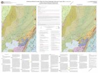
This map is an interim product and will be superseded by an updated bedrock map of the quadrangle in 2016. This map is a digital version of USGS OFR 75-658: http://pubs.er.usgs.gov/publication/ofr75658 There are some cartographic errors in creating a digital version: A Jurassic diabase dike along the western edge of the quadrangle is not shown in the digital version. These errors are being corrected. | |
| Map Scale | 1:24000 |
biblio thumbnail:
Download links (PDF):
Download links (GIS):
For more info contact: