| Title | [Draft] Surficial materials map of the Marlborough quadrangle, Massachusetts |
| Publication Type | Map |
| 2004 | |
| Authors | Stone, BD, C.T., H, Mabee, SB |
| Series Title | Open-File Report |
| Massachusetts Geological Survey | |
| #MGSPub, #Subsurface, #SurficialMaps, 3D, Ashland, Berlin, glacial, Hopkinton, Hudson, Malborough, Northborough, outwash, Southborough, stratified drift, surficial, till, Westborough | |
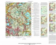
This map shows the stacked vertical distribution of nonlithified surficial earth materials within the Marlborough quadrangle. This series of maps shows these deposits as they are vertically arranged in units from bottom to top. Surficial materials include mineral and rock particles in glacial deposits, and mineral, rock, and organic particles in postglacial deposits. Surficial materials also are known in engineering classifications as unconsolidated soils, which include coarse grained soils, fine grained soils, or organic fine grained soils. Surficial materials underlie and are the parent materials of modem pedogenic soils which have developed in them at the land surface. Delineation of the materials is based on surficial geologic mapping (Stone, 1978, Hildreth, 2003, 2004), the identification of glacial meltwater morphosequence deposits, knowledge of the deglaciation history of New England, and examination of borehole logs and water well records. For this set of maps, glacial meltwater deposits are distinguished by their geomorphologic expression, sediment type, and depositional environment. These deposits are further subdivided into a series of related glacial sedimentary facies, which are stacked vertically within each glaciaodeltaic or lake-bottom deposit. Postglacial deposits at the land surface are differentiated by their sediment type and geomorphic expression. The principal surficial materials map shows the distribution of these materials exposed at land surface. The smaller inset maps (maps A-F) show the surface and subsurface distribution of the glacial meltwater deposits , including the distribution of specific sedimentary facies that compose these meltwater deposits. By using each inset map in sequence both the lateral extent and vertical arrangement of the deposits at a particular location can be estimated from bottom to top. | |
GIS Files and metadata forthcoming | |
| Map Scale | 1:24000 |