
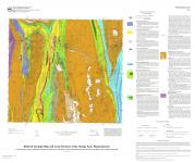
| Title | Preliminary bedrock geologic map of the Orange 7.5' quadrangle, Massachusetts (including portions of the Millers Falls and Athol 7.5' quadrangles) |
| Publication Type | Map |
| 2008 | |
| Authors | Robinson, P, Fernandez, M |
| Series Title | Open File Report |
| Edition | OFR08-04 |
| Massachusetts Geological Survey | |
| #BedrockMaps, #MGSPub, AMMONOOSUC, Athol, ATHOL FAULT, BEARS DEN FAULT, BEDROCK, BRONSON HILL, ERVING, GEOLOGIC MAP, GEOLOGY, LITTLETON, map, METAMORPHIC, MGS Publication, New Salem, Orange, PELHAM DOME, Petersham, Shutesbury, Warwick, Wendell | |
The culmination of over 50 years of mapping and geologic investigation by U-Mass professor Peter Robinson and his students, this map details the structure and stratigraphy of the Oliverean gneiss domes and the continuation of the Bronson Hill sequence south into central Massachusetts. | |
| Map Scale | 1:24000 |
biblio thumbnail:
Download links (PDF):
For more info contact: