| Title | Preliminary Bedrock Geologic Map of the Hudson 7.5' Quadrangle Worcester and Middlesex Counties, Massachusetts |
| Publication Type | Map |
| 2014 | |
| Authors | Kopera, JP, Hansen, WR |
| Series Title | Open File Report |
| Edition | 14-01 |
| Date Published | 09/2014 |
| Massachusetts Geological Survey | |
| #BedrockMaps, #MGSPub, acton granite, ayer granite, Berlin, Bolton, Boxborough, Clinton-Newbury Fault, gneiss, Harvard, Harvard Conglomerate, Hudson, magnetite, Malborough, marble, migmatite, nashoba, Stow, tadmuck brook schist, Vaughn Hills | |
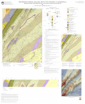
The Hudson quadrangle straddles the Clinton-Newbury Fault Zone (CNFZ), which separates low metamorphic grade Silurian turbiditic metasediments and Devonian plutons of the Nashua sub-belt (Robinson and Goldsmith, 1991) of the Merrimack Terrane to the northwest from the high-grade, migmatitic Cambro- Ordovician arc-complex of the Nashoba Terrane (Walsh et al., 2011; Loan 2011). This general area comprises the suture between the Gander and Avalon composite terranes of the Northern Appalachians (cf. Hibbard et al., 2006). Metasedimentary rocks of the Merrimack Terrane are generally poorly exposed, with intrusives (Day, Dayp, SDgdt) and the Clinton-Newbury Fault zone and associated rocks (Ot) forming a prominent northeast trending ridge (Oak Hill in the town of Harvard) marking the eastern bordering slope of the Worcester Plateau (Emerson, 1917, p. 16). Elevation and local topographic relief gradually decreases and glacial cover increases to the east-southeast across the strike of the Nashoba Formation, which, locally, forms low-relief NE-trending strike-parallel ridges. These are cut by dramatic cross-strike cliffs and glacial spillway gorges developed along cross-strike joints and brittle faults, most notably on the western slopes of Rattlesnake Hill, southern slope of Powder House Hill and in Camp Resolute in Bolton in the west-central portion of the quadrangle, and the southern slope of the hill along the west side of Codman Hill Road in Harvard in the north-central portion of the quadrangle. The migmatitic ortho- and paragneisses, schists and associated metavolcanic rocks of the Nashoba Formation (_Sn) form a northeast striking belt underlying the southern two-thirds of the quadrangle. These are intruded by a variety of presumed Ordovician to Silurian intermediate intrusives (OSd, OSaqd) and Devonian or younger tonalites to granites (Dan, Danp, Dac). | |
Note: This map supersedes "Preliminary bedrock geologic map of the Hudson quadrangle, Massachusetts", MGS map published in 2005 Report accompanies map-- be sure to download both! |