| Title | Progress map of the preliminary bedrock geologic map of the Billerica quadrangle, Massachusetts |
| Publication Type | Map |
| 2011 | |
| Authors | Massey, MA |
| Edition | OFR11-03 |
| Massachusetts Geological Survey | |
| #BedrockMaps, #FractureMaps, #MGSPub, Bedford, Berwick formation, Billerica, Billerica Schist, Boxford formation, Carlisle, Chelmsford, Clinton-Newbury Fault Zone, Concord, fracture, gneiss, joints, Lowell, magnetite, migmatite, nashoba, schist, Spencer Brook Fault, tadmuck brook schist, Tewksbury | |
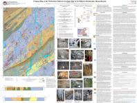
This map also contains brittle fracture data as part of the GIS files. This map is a progress report of bedrock geologic mapping currently underway in the Billerica quadrangle. It is a compilation of ongoing field mapping (Massey, this study) and previously published work in the area (Alvord, 1973, 1975; Jahns et al.1959). The Billerica quadrangle is located approximately 20 miles northwest of Boston along Route 3, just south of Lowell, in northeastern Massachusetts, encompassing the northwestern most Nashoba terrane and it’s boundary with the Merrimack belt (Figure 1). In the Billerica quadrangle, the Merrimack Belt consists of limited exposures of highly strained metasediments, or possibly orthoschist derived from reconstituted igne- ous protolith. The Clinton-Newbury fault zone separates the Merrimack Belt from multiply deformed, polymetamorphic biotite gneisses, migmatites, and amphibolites of the Nashoba terrane. | |
| Map Scale | 1:24000 |